
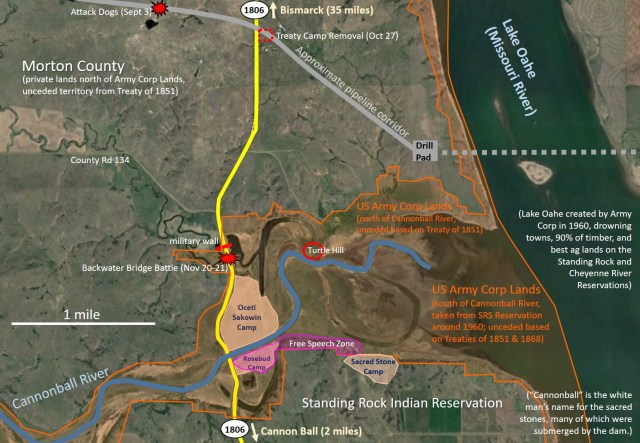
 I created the above map based on a variety of sources– maps released by the US Army Corp, the Environmental Assessment by Energy Transfer Partners, Google Earth, drone footage by Digital Smoke Signals, and information at Oceti Sakowin Camp and Sacred Stones Camp. All locations are approximate.
Backwater Bridge (where Sophia Wilansky was severely injured), the military wall across Highway 1806, Turtle Hill (which has been taken over by law enforcement and barricaded with razor wire), and the waterside locations from which state and local law enforcement sprayed mace and pepper spray on non-violent people standing in the water are all clearly on federal land. Thus, the militarized state and local militias, as well as oil company private security forces (aka mercenaries) have clearly been using their brutal tactics with Army Corp permission on federal land.
This is critically important. In general, states and counties have no formal relationships with tribes (unless otherwise arranged). The federal government, however, has a legal nation-to-nation relationship with tribes. They cannot conduct or allow any action on federal land that affects tribes without formal tribal consultation. And they cannot violate treaty obligations.
With the Army Corp now demanding that Oceti Sakowin Camp be cleared by December 5, and 600 federal military veterans promising to self-deploy to support the tribe, a federal showdown now looms.

View from above Highway 1806 looking south at the military wall, the backwater bridge, and Oceti Sakowin Camp.
Here are some of my previous posts on Standing Rock and the Dakota Access Pipeline:
-
Time for pressure: What you can do for Standing Rock now (about banks to protest, and Obama’s limited options)
-
The Dakota Access Pipeline doesn’t make economic sense anymore (about the rapid decline in Bakken oil production, making the pipeline unnecessary)
-
Standing Rock: America’s War Zone (about the militarized state of affairs in the area)
-
Standing Rock Update: Non-violence vs 7-State Army (about the removal of the Treaty Camp on Oct 28)
-
Upside-Down Flags, Standing Rock, and the Dakota Access Pipeline Protest: Background and Basic Facts (with lots of historical context)
-
Havoc, the Dakota Access Pipeline, and the Dogs of War (about parallels to the use of dogs by conquistadors of the past)
A future post will explore Bakken oil and spill risk.

Pingback: A Showdown Looms at Standing Rock – #NoDAPL