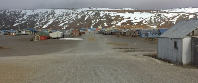
Main street in Gambell, St. Lawrence Island, Alaska.

Yesterday’s bowhead whale on the beach between the town and the point.
In the middle of the Bering Sea, where the only other visible land are the gleaming snow-clad peaks of the Russian Far East, two cultures meet in a strange symbiotic juxtaposition. Gambell is a Siberian Yupik village, named for the missionary that lived there for a few years in the 1890s. Its original name was Sivuqaq, still a widely used moniker. Its seven hundred residents are packed into small box houses on a gravel plain  on the northeast tip of St. Lawrence Island. Because of its location, midway between North America and Asia, it attracts an extraordinary collection of bird life. Seabirds wing around the point, en route from wintering areas in the Pacific to breeding grounds in the Arctic. Migrating songbirds, both Asian and American, find it a literal island in a storm.

A “Siberian” Common Chiffchaff, of which there are fewer than 15 North American records.
It’s the latter feature that attracts the birders, hardcore “listers”, mostly from the Lower 48, keying in on Asian vagrant songbirds and the fact that the American Birding Association, perhaps relying more on political boundaries than natural geography, considers the island “North America”. During spring and fall migration, birders can add an eye-popping list of mega-rarities to their North American list in just a few days. Personally, I saw Eyebrowed Thrush, Common Chiffchaff, and Pallas’s Bunting in my first forty-eight hours there.

Crested Auklets with a Least Auklet; the Yupik occasionally hunt the former.
The birding here is quite different from a peaceful saunter in the woods back home, and it’s not for everyone. It takes on the feel of a military operation on frozen tundra. A group of birders may be seeking a warming break from the thirty-three-degree air in the lodge, which has all the accoutrements of a double-wide used by a duck club. Another group, from a different tour operator, may be out at the point, braving the chill wind at a “seawatch”. Some unaffiliated “independents” may be elsewhere around the village, down along the lake, or over at the seabird nesting cliffs.
Simultaneously, all of their walkie-talkies crackle with a report of an Asian vagrant at the Far Boneyard. This is an ancient village site, a midden littered with walrus bones and other artifacts from thousands of years of human survival in an icy world rich with marine life. The decomposing nutrients of the bones create fertile soil for various grasses and plants, which in turn attract birds in this treeless landscape. There is the Near Boneyard, the Far Boneyard, and the Circular Boneyard, all within a short walk of the current townsite.
But walking is a chore here, slogging thru deep pebble gravel. It warms you up, strengthens your ankles, and wears you out. The birders jump on their ATV’s (called “Hondas” by the locals) and rumble to their destination. The twenty-Honda convoy rumbles through the village, swings to one side of the boneyard, everyone hops off, and then forty birders, for they all rode double, assemble into formation. Spread out in a line, they walk in lock step, sweeping the boneyard for any movement with their Swarovski binoculars, Leica scopes, and Canon 400mm lenses, the total cost of which just about equals the $8,000 per capita income for Gambell. When one considers that a few days on Gambell, including airfare from Nome, lodging, and Honda rental, will set you back a thousand dollars or more, those who travel here are only the most dedicated, committed, or obsessed.


An umiaq frame, to be covered with walrus hide for hunting whales.
The native Yupik are likewise determined, though they use nature in a different way. While the birders are, in general, wealthy, older, and white, the Yupik are poor, eking out an existence that utilizes both subsistence hunting and modern entrepreneurship to make ends meet. For them, nature is a resource they have relied on for thousands of years and, despite a connection to the modern world, they still rely on it extensively.
They take a few bowhead whales each spring, physically throwing an explosive-tipped harpoon from a small skiff (called an umiaq) powered by a small outboard motor. In the old days they used sails, which the elders still prefer. The skiff may be aluminum or walrus-hide.
When we were there, they brought in a minke whale, which they take when they can get them. The meat is shared around the community, but the credit went to the seventeen-year old at the helm of the harpoonist’s boat. We also saw many gray whales migrating past, but these are not typically on the Yupik menu. Racks outside some of the homes were hung with seal meat, drying in the Arctic sun.
For anyone questioning the morality of subsistence whale hunting, and for any birder about to visit Gambell or Utqiaġvik (Barrow), I recommend you read Whale Snow:

Seal meat left to dry on a rack.
The primary target of the islanders is the walrus, prized for their ivory tusks. The St. Lawrence Islanders are known for their ivory carvings. But the walrus can only be hunted when the sea ice is thick enough to hold them and leads open to allow boat access. This past winter the ice did not arrive until January and was gone by late April, allowing few opportunities for a hunt.
The only news I received of the outside world while I was on the island was from an elder informing me that Trump had pulled out of the Paris climate agreement. Sitting in the Alaska Airlines boarding area in Nome a few days later, I listened to two women from the region bemoan the difficulties their hunters had this season. They talked like it was a one-off bad year, but we all know it’s not.
 Gambell felt like villages I’d been to in Africa, India, or the Amazon. Children were everywhere and had freedom to play. Twelve-year-olds jumped from rooftop to rooftop, ten-year-olds drove Hondas, and six-year-olds poled small rafts out across icy ponds. Dust swirled down the main street, dogs adopted homes (not the reverse), and the single general store was the central gathering place, festooned with notices about church activities, new cigarette prices, and the dates this summer when a dentist would visit. While the adults spoke Siberian Yupik to each other, the kids spoke English, suggesting their language may be vanishing like the sea ice.

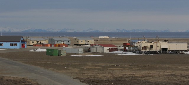
Seabirds wing past the point as the mountains of the Russian Far East define the horizon.
Yet Gambell’s isolation and latitude gives it a unique air. With twenty-four hours of daylight, the town seemed to come awake after noon, enjoy the slightly warmer evening, and to not retire until after midnight. The only exception to this was youth basketball practice, held outdoors at 7am in thirty-two-degree weather. Native Alaskan villages take their basketball seriously. The largest trophy on display in the general store, a multi-tiered two-foot-tall golden and fake marble masterpiece, was for first place in the Annual Gambell Shootout. The town is tethered to the outside world by four flights a day from Nome (two each from Ravn and Bering Air).

The passengers on our flight from Nome included me, my son, and lots of Dr. Pepper.
A doorknob or water heater part (for the lodge) can be requested by phone, purchased in Nome, and arrive in Gambell before the day is out. When a plane lands, a half dozen Hondas race from the village several hundred yards to the tarmac, help the pilot offload the boxes, and promptly bring the requested appliance parts to those who ordered them. A fuel barge arrives each summer, delivering the year’s supply of gasoline for the Hondas, heating oil for the household furnaces, and diesel for the local electricity generating plant, as well as any larger items that don’t fit on a small plane. They get television, and the young people that wash dishes in the lodge play hip hop on their iPhones while they work. The only other town on the hundred-mile-long island is Savoonga, which is thirty minutes by air or six hours by Honda. One man told me he did it in less than two hours in winter by snow mobile.
The entire island, all 1,800 square miles, is privately owned by the Sivuqaq and Savoonga Native Corporations. They hold the keys and access is a privilege. The birders are guests

Inside the store, where a bag of Doritos will set you back $12.
and must acquire a $50 “crossing permit” upon arrival. This allows them free reign to about two square miles, leaving burial sites and hunting areas for the locals. Even within this area, local hunters have priority over birders, and they do enjoy the occasional Crested Auklet or waterfowl to supplement the expensive canned goods from the general store. Even near Nome, I saw Alaska Natives harvesting Glaucous Gull eggs on an island in Safety Lagoon. They explained that, this early in the season, the birds will re-nest.
The relationship between the villagers and the birders, on a day to day basis, is a bit like two ships passing in the night, in that they rarely converse with each other, though they walk past, or ride past on their Hondas, each other all the time. I imagine it’s a bit like the relationship between Himalayan climbers and the Sherpa communities. Like the Sherpas, the Yupik reap an economic windfall from the birders. The lodge is owned by the community, by the Sivuqaq Native Corporation, and its proceeds are presumably distributed to meet community needs. The Hondas are rented by private individuals who post their names on a list. Every evening locals come into the lodge common area to offer ivory carvings, other art pieces, or even old artifacts from the boneyards for sale.

The dining hall in the lodge. It’s basic, but clean, with hot showers and a large kitchen.
Their sales pitches often include a personal note regarding their economic need such as what basic expense they can cover by selling this carving. To their credit, the birders bought generously.
The lodge was originally created as the barracks for the construction crew that built the large K-12 school, but was then converted into a guest lodge for tourists. Peak season is early June and late September, during spring and fall migration. During the rest of the year, the Yupik of Gambell are largely free of binocular-clad Honda caravans crossing back and forth through their village to chase the next Asian warbler. The mutually beneficial relationship is, in part, the work of dedicated souls from both communities, such as Paul Lehman and Clarence Irrigoo.

My son and me with Hansen Irrigoo, liaison between the lodge and the birders.
I met Clarence on my first day there. I was out in the Near Boneyard, walking among walrus bones, hoping to flush a mega-rarity. Off to my right, an old man was meandering about, seeming to be looking for something, and gradually drifting closer to me. I imagined he wanted to sell me an ivory carving, or perhaps tell me I was doing something wrong. Instead, his first words, difficult to understand because of his lack of teeth, were, “I found a thrush.” Without binoculars, he was birding, trying to help us. As he went on to describe it, his excitement conveyed he too enjoyed finding Asian vagrants. He told me he was leaving on the next plane, later that afternoon, to join a Russian research vessel to the north. “We’re going to see,” he jiggled with joy and his voice rose in anticipation, “so many walruses!”
“Will you be hunting them?”, I asked.
“No,” he replied. “Biopsies!”
He was just happy, after the dismal lack of sea ice and walrus this winter, to get a chance to be around his beloved animals. As for me, I was grateful the Yupik allowed us to come to their island.
Gambell, the Bering Sea, and the Russian Far East; June 1, 2017

 I was lucky to be out of town for a week during “the greatest statewide heat wave ever recorded in California.” When I arrived in Seattle, I was quickly informed that they had just set a record of 55 consecutive days without rain—and that the record would still be increasing had it not been for 0.02 inches late one night a few weeks earlier. Seattle has also set a number of heat records the past four summers. The same people that bragged about this “beautiful weather” scoffed that I believed in climate change. They asserted that no sea level rise would occur during our, our children’s, or our grandchildren’s lifetimes because, 1) Puget Sound was not really part of the ocean; and 2) those NOAA flood maps are “bureaucratic bullshit”. These same people live on the water in homes that are a few feet above current maximum high tides. Days later we all swept ashes off decks while marveling at the sun, which was reduced to a rosy red disc by smoke from a record 68 large uncontained fires burning across the West.


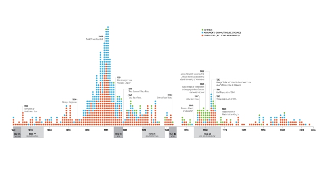 The Southern Poverty Law Center prepared this remarkable diagram, illustrating when Confederate symbols, such as statues, flags, and monuments, were erected in public places– mostly around 1910 and then again in the 1960s during the Civil Rights movement.
 Native mascots for universities and professional sports teams started in 1909 and really took off in the early to mid-1900s, when Natives were largely confined to reservations and no longer posed a military threat. Many Indian mascot names have since been revised.